Mapping Speed Limits of Malta’s Primary Roads - PAF
-
Introduction: Problem statement
Speeding has been flagged as the second largest concern with regards to traffic safety in the European Union (European Commission, 2010). In Malta, at least 3 persons a day require medical attention following a traffic accident, which presently occur at a 30-minute interval (Transport Malta, 2019). In 2018 alone, 38 road fatalities were recorded, translating into 1 road fatality for approximately every 10,000 people. Unlike many other member states, this number has increased by 7 deaths since 2010 rather than decreased (European Commission, 2019).
Transport Malta (TM) quotes the primary cause of traffic accidents to be due to speeding (2019), yet there is a lack of consolidated information regards national speed limits. Currently, existing speed limit signs were allocated by local counsels without much scientific/technical analysis (Transport Malta, 2012) and a national speed limit framework is still in the making, thus leaving a gap in terms of a single cohesive approach to speed limit management. The absence of such policies together with the shortage of informative signs and materials, creates several potential hazards for anyone using local roads and halts the implementation of a national speed enforcement policy and other road safety measures
(European Commission, 2019).
This project aims at collecting existing speed limit signs along primary roads across the island, in order to accumulate and publish previously missing data of local speed limits, which consequently is to be used to raise awareness around speeding on the local roads and road safety. Moreover, the results obtained from this exercise can be further used for a variety of purposes ranging from transport research, cohesive transport planning, traffic data collection and vehicle tracking (e.g. Boosh support), besides other proposed activities listed in the recommendation section below.
-
Methodology
2.1.Aim of the Study
The main objective of the proposed project is the development of a transport map tile for Open Street Map (OSM), including further information on Maltese roads. The project consists of data collection, inputting this data into OSM, and examining the status quo of speed limit signs in Malta, whilst utilizing the data to develop future projects around road safety for all modes of transport, including pedestrians.
Hence, the project aims to:
- Produce a Speed Limit inventory of local Primary (and partial Secondary) roads, openly available for any form of transport research
- Encourage safer roads in Malta by highlighting the high percentage of roads inadequately marked
- Advocate, using evidence-based research, for increased speed limit signage, consequently increasing road safety by reducing over-speeding
- Support future research into local transport concerns
- Facilitate the development of future apps or ICT products for transport, based on the collected data (please note that data was correct at time of writing but subject to change due to ongoing and future roadwork projects)
2.2.Research Design and Data Collection Tools
The project undertaken focused predominantly on the collection of speed limit signs along the Primary roads of Malta. Based upon the road classifications provided by Transport Malta (2012) and OSM, the Primary roads were identified accordingly. Since several Primary roads and villages were served by interconnecting roads, these Secondary roads were also mapped in order to create a more cohesive picture of the road network and to compare differences in speed limit values assigned to Primary and Secondary roads. Hence why throughout this document, Secondary roads will be referred to as partially mapped.
Since the aim of the project was to produce an inventory of speed limit signs, it was concluded that a field research approach was required alongside technical expertise of OSM. Field research would allow for the gathering of the data as is available on the local roads at present, thus increasing the validity and accuracy of the data inserted into OSM. The field research was carried out by mapping each speed limit sign whilst travelling along Primary (and partial Secondary) roads by car. Mapping of each sign was achieved by inserting the data in real-time into an App, specially designed for the field research. The use of this self-developed App permitted for minimal interruption during driving to record the posted speed limits, thus ensuring increased theoretical accuracy of up to 3 meters.
To complete this research, PAF acquired funding for a budget of 5000 Euros and hired two collaborators. The first being a GIS specialist, who was responsible for the creation of the specialized App needed for the field research and for entering the collected data into OSM, thus creating a map of the Maltese roads. The second collaborator acted as a mapper placed in the field to collect the speed limit data required using the aforementioned App. The research was carried out between May and August 2019 and was further supported by several volunteers, who contributed additional speed limit data on Gozo and other parts of Malta.
Once the field collection was completed, cross-verification of the data was carried out by PAF to confirm data accuracy. The data was then converted into a visual map presenting an inventory of the speed limits for Maltese Primary (and partial Secondary) roads. For further validation, the data was submitted to the OSM community and will upon completion be uploaded onto the open source platform.
-
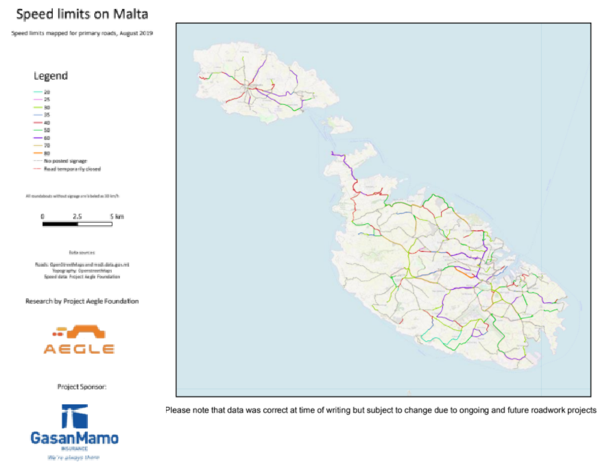
Results
The aim of the project was to map the available posted speed limits along Malta’s Primary (and partial Secondary) roads. In doing so, a visual representation could be created marking the existing speed limit signs and their assigned values. Consequently, this data allows for a present-day picture of Malta’s active speed limit structure, highlighting themes for further research and emphasizing the lacking infrastructure required to adhere to European road safety regulations.
3.1. Mapping
Although 100% of Maltese roads classified as Primary roads were mapped successfully, only 65.8% of these roads had speed limits signs. This implies that large sections of these roads are left undefined, hence it was not clear how far a speed limit’s value would be valid or even what the precise speed limit was for a particular road. These issues were raised in a document by Transport Malta in 2014 and remain so today. This posed an issue when inserting the data into OSM, resulting in some roads being assigned “no posted signage” and other stretches of road being assigned the value of the last speed limit point mapped.
3.2.Resulting Themes
From the results obtained, certain themes concerning speed limits and road safety arose:
- The lack of consistent posted speed limit signs
- Absence of regularly posted speed limit signs in accordance to European recommendations (European Commission, 2019)
- Primary roads consist of a variety of different types of topography, ranging from rural to national
- Primary roads crossing village cores
- Absence of posted speed limits on newly renovated roads
- Use of speed cameras is limited and act as the main speed limit enforcement method
4. Discussion and recommendations
4.1.Brief Discussion of Findings
As listed in the previous section, several themes stood out as a result of the data collected and inserted into OSM, which demand further attention.
The lack of general speed limit enforcement strategies may tie strongly into why speed limits are persistently not followed. Without the speed limit information consistently being repeated to road users in the form of posted speed limits (visible to all using the road), road users will struggle to adhere to the correct speed limits on any of the road they encounter. This sporadic availability of information possibly results in people filling in the blanks when it comes to speed limits or ignoring the few posted speed limits that are in place. There were several additional inconsistencies noted such as no posted speed limits following a junction (European Commission, 2019), or absence of posted speed limits on newly renovated roads on which new traffic regulations were implemented, each of which feed into the already existing misperceptions surrounding speed limits and speeding habits.
Moreover, not following speed limits may also be further related to the deficiency of other speed limit enforcements. It was noted that speed cameras are far and few between, leaving substantial stretches of road unmonitored. In addition, certain roads having speed cameras did not have any posted speed limits signs, which confused drivers who visibly were unsure on how to behave regards their vehicle’s speed. Several pedestrian crossings also pose a concern as drivers are not notified that such a crossing is approaching, and that the driver should slow down. Nor were any further speed limit enforcements present, such as sleeping police, which could forcibly slow the vehicle down if need be.
Another theme that stood out was how to effectively match a speed limit to a Primary road, keeping its topography and the surrounding infrastructure in mind. It was observed that some Primary roads cut across village cores, yet no indication of a change in speed limit was noted. This was also the case when the topography of the Primary road was reminiscent of a more rural configuration. In both cases it can be argued that these roads were assigned theoretically higher speed limits than the physical infrastructure could safely permit.
Lastly, when one steps out the driver’s seat and adopts an alternative mode of transport, such as walking or cycling, the current speed limit system would fail them enormously. As it stands, car users are at high risk of accidents caused by over speeding yet taking poor infrastructure and sporadic speed limit enforcement into account, this risk substantially increases for anyone outside of a car.
4.2.Recommendations
From the results collected, it is evident that more priority needs to be given to speed limit posting and enforcement. Malta requires a national speed limit management policy that will consequently facilitate a standardization of road functions and design, opening the Maltese roads to other forms of transport other than the private car.
Besides using this data to highlight the lacking infrastructure and the traffic related consequences thereof in the media, further pressure can be placed upon the TM and other authorities to take more action regards finalizing the national speed limit management policies and its implementation.
To complement this process, educational campaigns can be created to serve various spheres of society, ranging from Road Safety lessons at school to national campaigns focusing on spreading awareness of new policies and speed management strategies.
It must be noted that these recommendations go hand in hand. There is little use in educational and awareness campaigns being run across the country without any efforts being made to upgrade and firmly tackle current road infrastructure and speeding in a pro-active manner. This implies the introduction of further speed limit enforcement strategies such as speed cameras, sleeping police, higher fines and consistent presence of authorities on the road.
Here, this project can assist the ICT sector with regards to speed monitoring technology through the data collected. Knowledge of the posted speed limits can thus facilitate in the development of technology that could be implemented in vehicles to alert drivers of the speed limit and beyond.
Taking focus away from private cars and shifting it to more vulnerable road users such as pedestrians is paramount. Every citizen is a pedestrian at some point in their day and frequently fall victim of the current traffic situation, which is quintessentially car-centric, ignoring other modes of transport whilst extending a sense of entitlement to car drivers.
PAF strongly believes that through increasing road safety for young and old, opportunities will arise to enable a strong increase in multimodality transport. In turn, if roads can be safely shared by private cars, pedestrians and cyclists, current traffic congestion, environmental and health issues will dwindle.
-
References
[1]https://ec.europa.eu/transport/road_safety/specialist/knowledge/speed_enforcement/speed_enforc ement/speed_enforcement_as_part_of_a_speed_management_policy_en
[2]https://ec.europa.eu/transport/road_safety/specialist/knowledge/speed/speed_limits/current_speed _limit_policies_en
[3]https://ec.europa.eu/transport/road_safety/specialist/knowledge/speed/speed_limits/information_ab out_the_speed_limit_in_force_en
[4]https://ec.europa.eu/transport/road_safety/specialist/knowledge/speed/speed_limits/road_engineer ing_en
[5]https://ec.europa.eu/transport/road_safety/specialist/knowledge/speed/speed_limits/speed_enforce ment_en
[6] https://europa.eu/rapid/press-release_IP-19-1951_en.htm
[7] https://europa.eu/rapid/press-release_MEMO-10-344_en.htm
[8] https://europa.eu/rapid/press-release_MEMO-19-1990_en.htm
[9] https://www.transport.gov.mt/strategies/road-safety/speed-management-1348
[10] Transport Malta (2012). Speed Management on Maltese Roads Policy and Technical Guidance Manual Consultation Document Version 1.06c [PDF file]
Article provided by Esther Cuschieri Huy - Project Aegle Foundation.
No Comments